A Four Season Scenic Ride


In the North Georgia Mountains, we celebrate four gentle yet very distinct seasonal transitions, each measured very close to the designated tri-month celestial calendar. Mother Nature’s landscape specialist (shall we call her Flora?) takes a particular interest in altering our mountainscape on a quarterly basis, cloaking it in very different hues, depths of foliage, and fragrances.

To get a full appreciation of Flora’s artistry in any one of the seasonal changeovers, we encourage you to drive the 41 miles of Georgia’s only national scenic drive, The Russell-Brasstown Scenic Byway. The Byway, one of only 120  highways across our fifty states so designated, circles around the Chattahoochee National Forest and can be launched just seventeen miles southeast of Fannin County, at the intersection of Hwys 129 and 180, located in neighboring Union County.
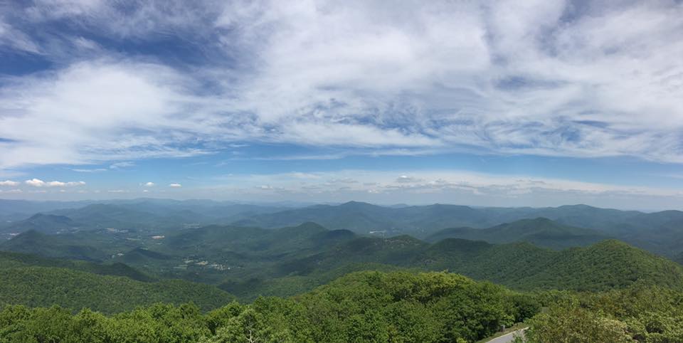
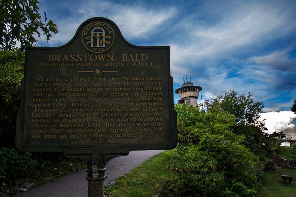
Highest Peak In GA

Following Hwy 180 northeast, you’ll travel twelve miles to the entrance to Brasstown Bald, the highest mountain elevation (4,784’) in Georgia. When you get to the top of the Bald’s observation tower, you will have a spectacular 360-degree view of three states!
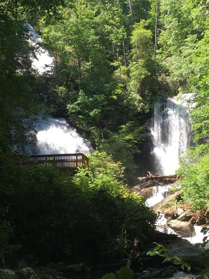
Photo Courtesy of Steve Grundy Photography

Anna Ruby Falls

Back on Hwy 180 and after heading southeast for ten miles, you will turn south onto Hwy 75/17. Over the next 10 miles, you will motor through some of the heaviest of forestry, including designated recreation areas Unicoi Gap and Andrews Cove. These are ideal places to hike, fish, picnic or just relax before heading out on the next part of your adventure. Driving for just a few minutes you will arrive at one of the region’s finest natural gems, Anna Ruby Falls. This double waterfall is formed from the merging of two creeks, both sourced from underground springs.

Anna Ruby Falls Photo Courtesy of Bill Mantooth

Just three more miles south you will find yourself at Unicoi State Park, where you can jet off on a bicycle, paddleboard on Unicoi Lake or eat at the Unicoi Restaurant located in the beautifully appointed Unicoi Lodge.
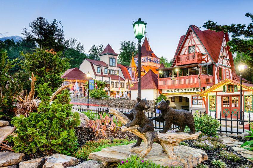
Alpine Helen

If you haven’t visited Bavaria’s USA sister city, quaint Helen GA, here’s the best opportunity, located just 3 more miles south of Unicoi State Park. But if Helen isn’t part of your plans for this scenic trip, then backtrack up 75/17 for only two miles where you’ll arrive at the entrance of one of the State’s most beautiful wooded parks, Smithgall Woods/Dukes Creek Falls State Park.  Covering over 5,600 acres, this Park focuses on conservation. It’s also an angler’s paradise with some of the very best trout fishing in the State on the waters of Dukes Creek. Visit their event calendar to see what is scheduled during your visit.
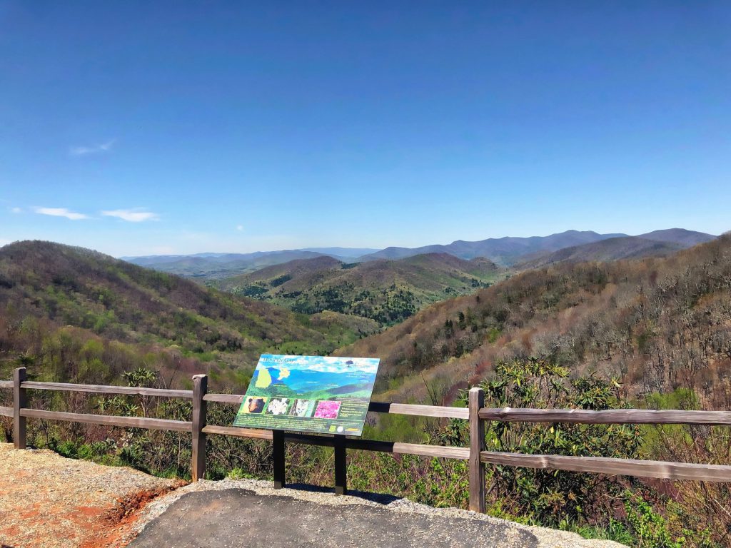
Photo Courtesy of Alpine Helen – White County Convention & Visitors Bureau

Hogpen Gap

There’s one more leg to this journey, and it is perhaps the most spectacular. Just a hair north of Smithgall Woods you will come upon the gateway (Hwy 348) to Richard Russell Scenic Hwy.  These next 23 miles are not only a favorite for motorists, bicyclists and motorcyclists, but wildlife also love to roam all over the cliffs and valleys along this route. Do drive with patience and caution.
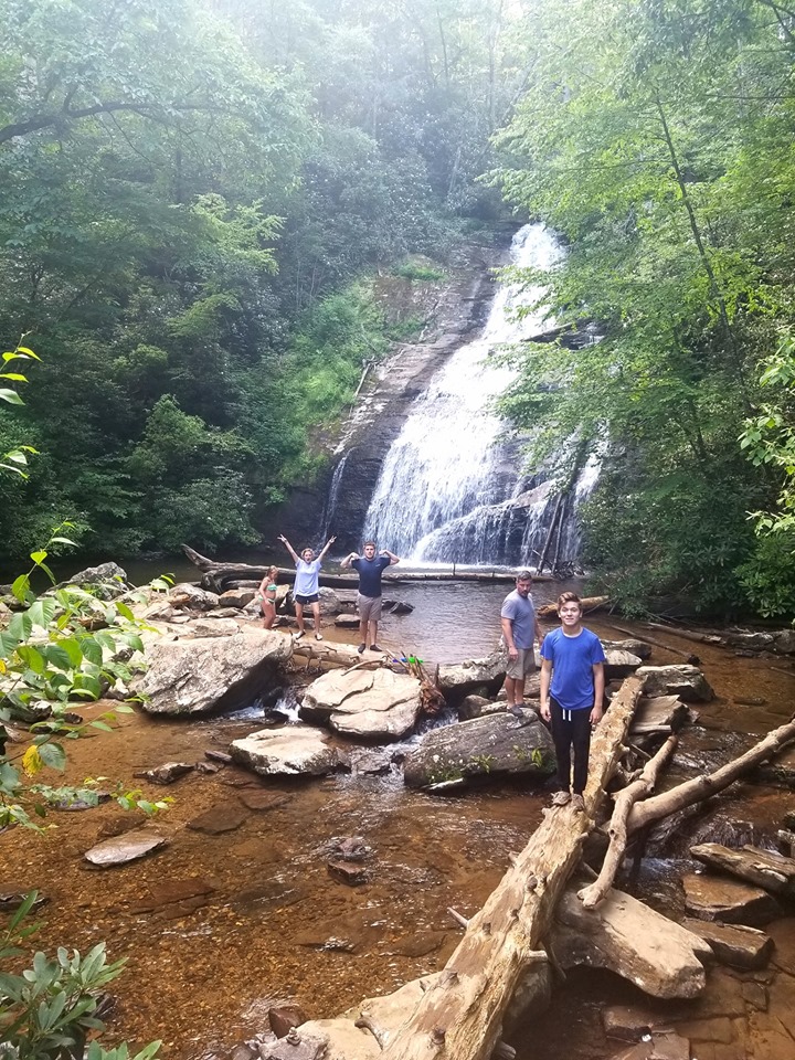
Hogpen Gap Photo Courtesy of Scott Michael Anna

Helton Creek Falls

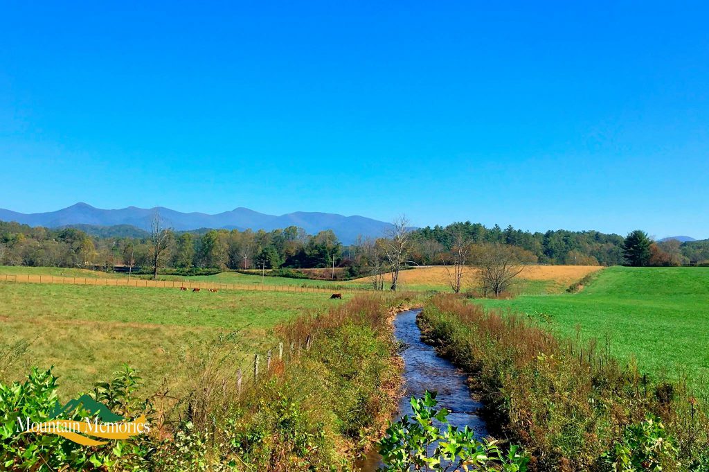
After nearly a 10 mile ascent, you’ll reach Hogpen Gap, (elevation 3,525′). This is a very popular, year-round hiking trail. But for just leaf lookers, the vistas at the appointed observation areas at this elevation are breathtaking! And in the spring there is no better place to view the “greening of the mountains”. As you begin the steep descent traveling north on Richard Russell, the valley brings more surprises as the fields open up and the farmlands, an integral facet of life in historical Choestoe Valley, are dotted across the highway. Look for a turn heading west at Hatchett Creek Rd. Follow this road till it merges with Helton Creek Road and visit one of the area’s favorite family waterfalls, Helton Creek Falls. The short hike (.24 miles) from the parking area leads to two falls. The lower falls has a wading pool area. The upper falls has an observation deck with bench seating.

Helton Creek Falls Photo Courtesy of Molly Carreras

Seasons of Fun!

Russell-Brasstown Scenic Byway is a 4 season wonderland. In the spring the hiking trails boast 1500 varieties of wildflowers with over 200 plants indigenous to just this Southern Appalachian region. 

Stop, look and listen and you’ll see fawn and bear cubs emerging from the woods, beavers building dams to reroute the heavy spring rainwater, and you’ll hear the songbirds who’ve migrated back to these mountains from their winter retreats.

Open the windows on your summer drive and capture the fragrances of the season as you pass cavernous areas of native azalea, rhododendron and mountain laurel. The farmers cut hay around Memorial Day and again at Labor Day. The smell of fresh-cut hay, watching the baling process or just coming upon a field of hay bales peppering the countryside all leave an indelible imprint on one’s senses.

Photo Courtesy of Mountain Mem’ries Photography

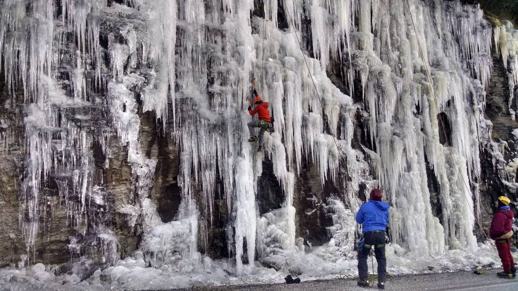
Summer visits to the waterfalls along this road will often find the thunderous waters framed by a rainbow. And as the days become shorter and autumn ushers in, the forest canopy bursts with vibrant colors as the sweetgum, red maples, and oak trees display their final fashion before shedding their foliage. In winter the starkness of the bare forest, covered in frost is an incredible photo opportunity. The cliffs near Hogpen Gap are covered with ice and a favorite spot for ice climbers to hone their skills.

Plan on this driving adventure the next time you visit us. It promises to impress you, whatever the season. Share your adventures with us by tagging #escapetobr on your social posts. Enjoy!

Fall in Love with Blue Ridge


Fall took a little longer than usual to arrive this year, but as soon as we had our first frost, BAM, the colors started popping! Now everywhere you look you can find brilliant reds, oranges, and yellows. So, grab your favorite boots and cozy sweater and Escape to Blue Ridge for leaf peeping at its best!

3 Falls and a Car

The Russell-Brasstown Scenic Byway is a nationally designated Scenic Byway that is 40.64 miles in length and makes a loop through the heart of the Chattahoochee National Forest.  Beginning in Blairsville take Hwy 129 South towards Blood Mountain. Turn left on Hwy 180 then right onto Hwy 348 – The Russell-Brasstown Scenic Byway. Along the way, you will pass Hatchet Creek Road that leads to Helton Creek Falls. Stop and enjoy both the Upper and Lower falls. The hike is short and easy, less than a mile long and super rewarding!

Continue up the mountain passing Tesnatee Gap, home to the original Old Logan Turnpike Trail. Just around the bend you’ll find Hogpen Gap which has an amazing overlook and picture-perfect opportunities. If you are up for a more challenging waterfall hike, Hwy 348 passes right by the trail-head for Raven Cliff Falls. While Raven Cliff is one of Georgia’s most popular waterfalls, be prepared to take a 2.5-mile journey through the woods.

The last waterfall opportunity on your travels down the Russell-Brasstown Byway is at Dukes Creek Falls. A happy medium between Helton Creek and Raven Cliff, Dukes Creek Falls is a two mile round-trip hike. Passing several small falls along the way, you’ll be rewarded at the end of the trail with a 150 foot, multi-tiered waterfall.  The Russell-Brasstown byway dead ends into Hwy 75 which will take you into the Alpine Village of Helen, Georgia.

See 4 States

The Southern Highroads Trail can be traveled in its entirety or in sections.  This very scenic route travels through four national forests (Chattahoochee, Nantahala, Cherokee, and Sumter) and four states (North Carolina, South Carolina, Tennessee and Georgia).  Enjoy shopping, dining, entertainment and outdoor activities in all 13 counties the route passes through.

Another way to see four states without all the mileage is to visit the top of Brasstown Bald. The approach to the Bald is worth the car ride alone. Turning onto Hwy 180 from Hwy 129 South in Blairsville, travel approx. 9 miles to Spur 180. Wind yourself up the mountain and be cautious of the hairpin turns, they’re liable to take your breath. Once you get to the top parking area, you still have another mile to go to reach the highest peak in Georgia at 4,784 feet above sea level! You can choose to hike the steep summit trail or take a shuttle bus up to the top. Either way, you will enjoy a breathtaking 360 degree view of four states (North Carolina, South Carolina, Tennessee and Georgia) from the observation deck. Inside you’ll find a museum featuring Georgia and Native American History. It is even said that you can see the Atlanta skyline on a clear day from the top of the Bald!

An Adventure

Just on the other side of downtown Blue Ridge, you’ll find the outdoor adventure area of the Aska Trail Systems. Here you can hike, fish, bike, and leaf peep. Being that Blue Ridge is the Trout Capital of Georgia, access to the Toccoa River is just off Aska Road. If you get hungry the Toccoa Riverside Restaurant is ready to serve you fresh trout, a top sirloin or a plethora of sandwich and salad options. They even have a full Pooch Porch Goodies menu featuring canine cuisines for Fido!

Whether you are biking or hiking, you can choose from strenuous to moderate trails. Our favorite is the hike down to Fall Branch Falls. This is a short half mile, family friendly hike that follows the Benton MacKaye Trail and ends at one of the most beautiful waterfalls in Georgia. The trail is mildly challenging, and the path is mostly uphill, but it is definitely worth the effort! As you approach you will hear the roar of the falls get louder as you near the multi-tiered falls. Notice a short side trail and take this down to the observation deck.

Pinnacle of Beauty

If you really want a mountain experience, you need to take the back roads and experience the simple life we enjoy here in the mountains. Take Highway 60 towards Dahlonega. Start your trip off right with a wine tasting at the picturesque Serenberry Vineyards. When you’ve built up your nerves of steel you can test your balance on the Swinging Bridge. This 270-foot-long suspension bridge is the longest swinging bridge east of the Mississippi River!

Continue down highway 60 to Georgia’s best secret, Suches, or the Valley Above the Clouds. At 3k feet above sea level, the Suches area provides a stunning view of picture perfect landscapes and glorious mountain views. Here you’ll also find the smallest public school in Georgia educating children from Kindergarten through 12th grade all in one building.

Take Hwy 180 to Lake Winfield Scott. This secret hideaway is a recreation area in the Chattahoochee National Forest. With a beautiful lake as the centerpiece, Winfield Scott beckons you to get out of the car, stretch your legs and take in the untouched beauty of this special part of Georgia. Continue down Hwy 180 with its hairpin turns and lush forest to Vogel State Park, Gerogia’s most beloved State Park. Here you can enjoy the beauty of Lake Trahlyta and take a short walk down to Trahlyta Falls.

Legend Has It

So interesting fact, Lake Trahlyta was named after a Cherokee Indian Princess.  Vogel State Park is located at the base of Blood Mountain where the Native Americans fought many years ago. They say that Slaughter Creek, which runs adjacent to Blood Mountain ran red for 3 days with all the blood that was shed. Lake Winfield Scott, just above, Vogel and Lake Trahlyta, was named after the General that led the Indians out on the Trail of Tears. You can take the full Suches loop around and pass by Trahlyta’s grave which is the rock pile at Stonepile Gap. Legend has it that if you stop and place a rock on Trahlyta’s grave, you too can be as young and happy as she once was.

Photo of Lake Winfield Scott courtesy of Gene Crawford.